


MOUNT PLEASANT, S.C. (AP) - Charleston County’s proposal to widen S.C. Highway 41 has drawn thousands of public comments.
Some supporters call the road through the historic Black community of Phillips the cost-effective, obvious choice.
Others decried it as a discriminatory plan that puts the burden on those with least political power.
“Who was surprised when the route through the Phillips community was chosen? No one should have been,” Charleston resident Dale Davis said in his response.
He called the proposal “the epitome of white privilege.”
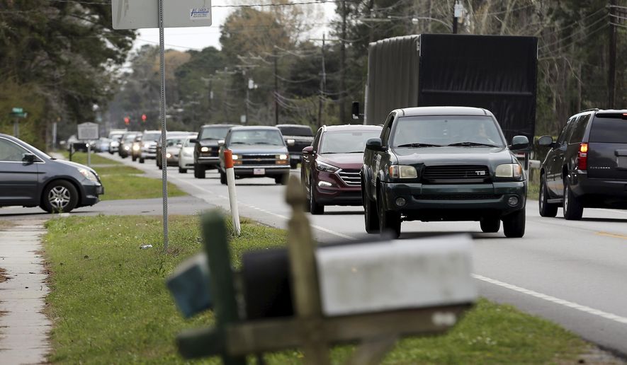
The Post and Courier reviewed more than 1,800 public comments - two-thirds of the total submitted - and just over half opposed the county’s leading plan that puts Phillips at risk. The input came as the two-lane road at the north end of Mount Pleasant has become jammed with traffic as large subdivisions were developed nearby. Charleston County has spent four years developing solutions, but each of the more than a dozen plans considered created winners, losers and controversy.
Now, the county is down to just two options and the battle lines are clearly drawn.
The “preferred” plan would widen Highway 41 to five lanes, running through Phillips, a community settled by formerly enslaved Black residents in the late 1800s. The $125 million plan is known as Alternative 1 because it was the first option the county’s traffic planners considered.
Some of the commenters see that as the easiest solution.
“Alternative 1 is the only alternative!” commented Jeff Wood, who said he was speaking on behalf of homeowners along Bessemer Road in Dunes West. “We teach our children that the shortest distance between two points is a straight line.”
Highway 41 begins at U.S. Highway 17 in Mount Pleasant and runs to the North Carolina border. The less-than-5-mile stretch from Highway 17 to the Wando River is the focus of the county’s planning, which includes redesigning the intersection of the two highways.
Homes along Bessemer Road would see significant impacts, and some would qualify for sound barriers, if Charleston County were to choose the one remaining plan traffic planners haven’t ruled out.
That plan, Alternative 7A, would largely bypass Phillips by routing traffic through the edge of Laurel Hill County Park, near Bessemer Road, to Dunes West Boulevard, before reconnecting with Highway 41. At one point the county said that plan would improve traffic the most, but amid a flurry of opposition, traffic planners said further studies showed that Alternative 1 was the best choice.
At the heart of the controversy there’s some agreement that traffic must be addressed, but no one wants a five-lane road in front of their home, creating noise and safety issues. And in Phillips, no one wants the government to take family land that formerly enslaved ancestors purchased.
“I’m not saying we’re going to do Alternative 1, but there has to be some fix for Highway 41,” said Charleston County Council Chairman Elliott Summey. “I think everyone’s acknowledged there’s a safety issue.”
“I’ll tell you this, no one on council is making a decision based on putting it through a Black community versus a White community,” he said. “It’s certainly not the way I look at it.”
In public comments, supporters of the Alternative 1 plan generally didn’t see the issue as race-related, but many of the opponents did.
“Since the Mother Emanuel massacre I have tried to understand issues of race,” said Clarence Legerton of Mount Pleasant. “One of the terms I have learned is systemic racism (and) I can think of no better example than this proposal.”
Supporters of the plan, citing Charleston County’s planning documents, say Alternative 1 would cost less, improve traffic more, impact fewer wetlands and directly impact fewer homes.
The outpouring of nearly 2,900 public comments prompted Charleston County to postpone a presentation of the Highway 41 plan to County Council this week so that staff can review and tabulate the comments. The presentation will happen some time in November, a county spokesman said.
“Certainly, we want to hear from the public, but it’s not whoever has the most votes wins,” Summey said. “It’s our job to do a deeper dive and make a decision based on the facts we’re given.”
Many comments on both sides were driven by groups that encouraged people to submit them. In some cases, multiple members of the same family submitted similar comments. One man submitted 10 comments himself. (The Post and Courier’s review screened out duplicates.)
Community associations from the large modern subdivisions along Highway 41, and particularly Dunes West, rallied supporters to file comments. So did some of the many groups opposed to the Alternative 1 plan, including The Coastal Conservation League, Historic Charleston Foundation, Charleston Preservation Society, Save Shem Creek, Charleston Moves, Lowcountry Land Trust, East Cooper Land Trust, Southern Environmental Law Center, Center for Heirs Property Preservation and Charleston Trident Association of Realtors.
The “pro” version of the cut-and-paste comments was: “As a taxpayer and voter in Charleston County, it is important that my hard-earned tax dollars be spent wisely. Alternative 1 meets the project’s needs and budget, while Alternative 7A exceeds the budget and is $30 million more expensive.”
The “con” version was: “I am a Charleston County taxpayer and I do not want my tax dollars to be spent on Highway 41 Alternative 1. I will not contribute to the destruction of the historic Phillips community, which was founded on land purchased by freedmen in the 1870s.”
Both supporters and opponents of the county’s preferred plan criticized Mount Pleasant and Charleston County for allowing thousands of homes to be built without addressing the traffic that would surely follow.
“This would not have been necessary had the proper advanced planning occurred, by not allowing the excessive building which caused excessive population and traffic,” said Charlotte Levin, supporting Alternative 1.
Some, citing reports in The Post and Courier, also said they were concerned that some Phillips residents could lose family-owned land for the road project but receive no payment.
That could happen because many properties in the community are heirs’ properties - land that’s been passed down informally through generations and is jointly owned by all descendants - and it’s not possible to determine the owners, in order to compensate them for taking their land, without tracing the family history and clearing up the title to the land.
“This makes it all the more awful to the people of the Phillips community and other African American properties that the national highways go through,” said Mary Bell of Mount Pleasant.
Some supporters of Alternative 1 didn’t see much worth preserving in Phillips.
“The Phillips community houses are ramshackle and need to go; what exactly is there to preserve?” said John Hamill. “However, please reimburse the Phillips people fairly for their trouble, and send them on their way.”
It would not be the first time Highway 41 has impacted land in Phillips. The once-dirt road was realigned and paved through the community in the 1940s.
“I recall my grandparents sadly and regretfully telling us of having to give up land from this parcel for an earlier widening of the same Highway 41,” Seaward R. Middleton, who inherited land in Phillips, said in a comment opposing the plan. “Now, decades later, here we are facing the same battle that they and their neighbors faced and lost well over a half-century ago.”
Phillips has the history, but Dunes West and Park West have far more residents. The modern subdivisions also have higher property values and lots of homes built near existing roads - all factors that raise the cost of Alternative 7A because home density and property values determine the need for expensive sound barriers.
There’s no firm timeline for a county decision, and the project still awaits review by the Army Corps of Engineers. However, Charleston County Council has a history of taking an active role in traffic projects, in some cases making changes or scrapping projects entirely.
With Highway 41, it appears clear that any plan to address the traffic will involve taking private property, adding pavement and infuriating a large number of residents who live in the area - all at great expense.
Please read our comment policy before commenting.